The Harriet on Riley Park
1200 Block of 5 Ave NW
Redesignation Application for a Direct Control Bylaw based on M-H3
LOC2025-0133
Introduction
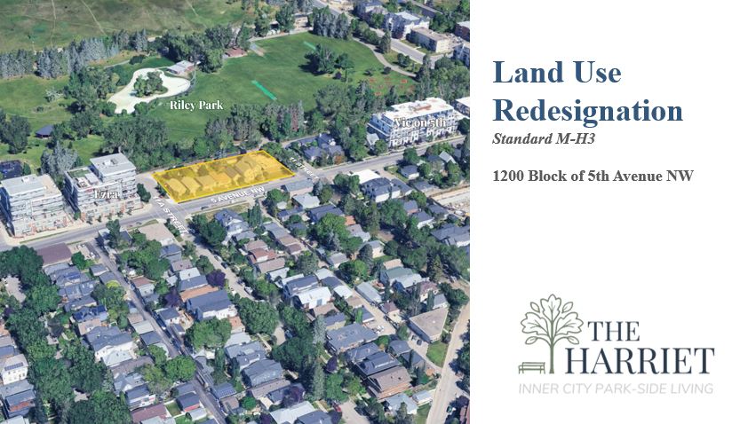
The Harriet on Riley Park is a new development proposed within the community of Hillhurst located immediately south of Riley Park on 5th Avenue NW next to the Ezra building.
The development is named after Harriet Waterhouse Riley, the wife of Ezra Riley, a politician and rancher, who donated the land that is now Riley Park to the City of Calgary in 1910.
The development of the parcel seeks to align the zoning and design with the Riley Communities Local Area Plan (LAP) through a redesignation application and development permit, applying the policies and targets within the document and in consultation with the Hillhurst Sunnyside Community Association (HSCA), neighbours, local stakeholders, and City of Calgary administration staff.
About the Site:
The parcel of eight lots comprises a full city block that is bordered to the North by a lane and Riley Park and is addressed to the South on 5th Avenue NW, situated between 11A St NW and 11 St NW, in the community of Hillhurst. The parcel currently contains 5 single-family homes, one duplex, and an apartment building (on the East end).
The surrounding context is the multi-family two-tower Ezra development to the West, and single-family homes and the Victoria on 5th building to the East. Across 5th Avenue are a vacant lot slated for redevelopment into multi-family small-scale building and single family homes.
The parcel is located 320 meters from the Sunnyside CTrain station, within the Transit Oriented Development area, and the Fifth Avenue bike path runs along the South side of the parcel.
1200 Block of 5 Ave NW
1220, 1218, 1214, 1212, 1210, 1206,
1204, and 1202 – 5 Ave NW


Policies & Guides
Several statutory and policy documents govern this parcel including:
Municipal Development Plan
The site is located within the Residential – Developed – Inner City Area as identified on Map 1: Urban Structure in the Municipal Development Plan (MDP).
Section 2.2 of the MDP promotes a more compact urban form that locates a portion a new housing within higher intensity, mixed-use areas that are well connected to the PTN.
Section 2.2.5 of the MDP encourages growth and change in low density neighbourhoods to accommodate developments that respects the scale and built form of the existing community. The existing low-density residential identity and character of the neighbourhood should be respected while ensuring infill developments completement the established character of the area (Section 2.3.2).
Section 3.5.2 of the MDP states that Inner City sites may intensify if the intensification is consistent and compatible with the existing character of the neighbourhood. Intensification strategies should modesty intensity the area and maximize front door access to the street.
Section 2.4.2 of the MDP: Built Form Policies Site and Building Design – “f. iv. Minimizing the shadow and wind impacts on adjacent residential areas and parks and open spaces.”


Neighbourhood Connector,
Map 3: Urban Form (pg 23, LAP)
Riley Communities Local Area Plan (LAP)
The Riley Communities Local Area Plan (LAP) Land Use Policy section indicates that development in Neighbourhood Connector areas should support a higher frequency of units and entrances facing the street.
The LAP identifies the subject parcel as
Neighbourhood Connector in Map 3 Urban Form.
The maximum building height allowed is up to
12-storeys as per Building Scale Map 4.
Section 2.2.1.4 provides Land Use policy in the Neighbourhood Connector Urban Form category, stating that development should be primarily residential; and support a broad range and mic of housing types, unit structures and forms.
Section 2.2.1.5 states that Neighbourhood Connector areas are characterized by a broad range of housing types along higher activity, predominantly residential streets.

Mid-rise (12-storeys),
Map 4: Building Scale (pg 24, LAP)
Urban Design Review Panel (UDRP)
This project meets the criteria for referral to Urban Design Review Panel (as identified in the Guide to Urban Design Review) and will be referred to the Panel (UDRP) for review during the Development Permit application process.
The UDRP is a Council-appointed peer review group of professional architects, planners, landscape architects, and engineers. Through their varied professional expertise, they encourage high design standards by providing independent, “best practice” review and comment on the urban design and architecture of development applications.

Applications
To achieve the new Riley Communities Local Area Plan policies and targets, a redesignation (rezoning) is required. The redesignation is being submitted as a stand-alone application at this time.
A subsequent Development Permit application will be submitted during the Redesignation application process and will be tied to the approval of the redesignation by Council.
Redesignation (Rezoning) Application – LOC2025-0133
Application Differences
An application for Redesignation from the existing Direct Control (DC) Bylaw 2016D34 District to a standard Multi-Residential – High Density High Rise (M-H3) district has been submitted to the City.
The application seeks to codify:
- A height maximum height of 12-Storeys (40m) to
align with the LAP. - A Floor Area Ratio (FAR)* of 6.0, allowing up to 198,750 SF of development (although the maximum FAR may not be achieved due to set-backs and step-backs).
Within the Development Permit application:
- Setbacks and stepbacks on the upper floors will be used reduce the impact of shadow onto Riley Park and improve daylighting of residential units in the development.
- The narrow laneway to the North, will be proposed to be converting to a pedestrian area with a design that matches the Ezra development to the West.
* “Floor Area Ratio” is a zoning metric that defines the ratio of a building’s total floor area to the size of the land parcel on which it is built. The Ezra development is noted as having an FAR of 4.0 allowed in the DC bylaw, with an achieved FAR of 3.3).
Redesignation / Zoning primarily deals with what land can be used for and the general parameters that govern development including:
- Types of uses allowed
- Density of units
- Maximum height and overall size of building (FAR)
- Parking requirements
- Public realm requirements
- Height and shape of development (max. envelope, not design)
- Set-backs and step-backs required (max. envelope, not actual design)
- Levy contributions
- May include overarching design requirements
Development Permits focus on the detailed design, safety, and regulatory compliance for specific projects within the established zoning framework including:
- Detailed site plan review and approval
- Building design, layout, and materials
- Utility connections
- Safety and accessibility compliance
- Construction and operations review
Building Permits validate that the detailed design and construction plans adhere to the Alberta Building Code, Calgary’s building standards, and all safety regulations.
For reference graphics of massing models, elevations, and footprint, please visit this site on a desktop computer.
Enagement Materials & Information
Jan 16 - Open House Slideshow
If you missed the Open House on Jan 16, you can view the slides presented here in PDF form.
Includes circulation map, zoning envelopes, streetscape context, shadow studies, timeline, and draft models.
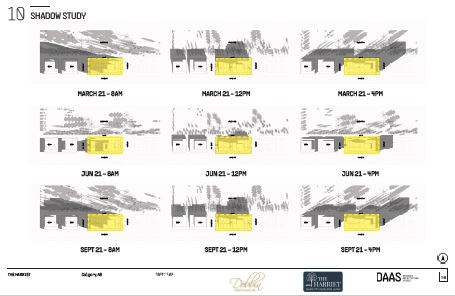
Draft Shadow Studies
The shadow studies are being updated based on the new M-H3 district zoning massing models to show the impact of the draft project design on Riley Park to the North.
Transportation Impact Assessment
This Transportation Impact Assessment (TIA) is based on the number of suites in the project and standard vehicle trips established by the City of Calgary for the area.
Public Engagement
This application is estimated to be a “1B” engagement rating on the Outreach Assessment Matrix from the City of Calgary requiring 4-6 outreach tools.
This application is utilizing nine of the Outreach Tools & Tactics to engage with stakeholders:
- This webpage for online engagement – EngageHarriet.com
- Direct Mailing/Emailing of printed materials
(to 1,000+ neighbours, see map to the right) - HSCA Planning Committee presentations
1st (DC bylaw) – May 26, 2025
2nd (M-H3 update) – Dec 8, 2026 - Public Open Houses
1st (DC bylaw) – Wednesday, May 28, 2025
2nd (M-H3 update) – Friday, Jan 16, 2026 - Ward 7 Councilor meetings
Completed with previous Councilor Wong
Booked with new Councillor Atkinson - Local Stakeholders (engaged)
HSCA the 5th Ave Bike Lane advocacy group - Onsite signage installed with QR code to website
- Email feedback form (below)
- Direct Contact email and phone provided (bottom of page)
The redesignation application was also reviewed by the Urban Design Review Panel and feedback was provided and integrated into early design and massing work.


What We Heard
Engagement is ongoing with the City and the Public. Our engagement and report follows the City’s Community Outreach for Planning & Development guides and format.
Engagement continues throughout the Land Use application and updates will be posted to this engagement website. Further engagement will be conducted with the building design prior to and during the subsequent Development Permit application.
1st Open House May 28
Engagement for original Direct Control, M-H2 based application, 6.0 FAR, 40M (12-storey)
At the first open house, approximately 15 community memebers shared feedback focused on parking and vehicle access, building height and shadowing, traffic safety, construction timing and impacts, and how engagement should be expanded (including better outreach to park users).
In response, the developer has explored alternative parkade access options, committed to EV charging, is revisiting entrances and visitor parking, is using step-backs and massing chnages to reduce shadows, and will broaden future engagement through expanded flyer delivery, park signage, and potential augmented reality tools during the development permit engagement.
Urban Design Review Panel (UDRP), Dec 10
M-H3 standard zoning (changed from DC once reviewed by Direct Control committee)
The Urban Design Review Panel (UDRP) expressed overall support for the project’s early massing, stepped height (up to 12 storeys), and inclusion of grade-oriented units, noting these elements contribute positively to pedestrian scale and vibrancy along 5 Avenue NW and the laneway. However, the Panel identified the need for significant refinement to better leverage the site’s adjacency to Riley Park and its gateway condition, recommending consolidation of back-of-house functions and parkade access on 11A Street NW, increased north and east setbacks with enhanced landscaping, and stronger activation along 11 Street NW. Additional comments emphasized improving public realm quality, legibility, and amenity clarity, including clearer intentions for at-grade uses (commercial vs. resident-only), enhanced plaza design at the southeast corner, stronger pedestrian connections to the park, and more explicit articulation of resilience and sustainability strategies as the design advances.
2nd Public Open House (M-H3) Jan 16
New massing, 6.0 FAR, 40M (12-storey)
75 community memebers attended and shared a wide range of feedback focused on building height, massing, and how the proposed development may affect the surrounding neighbourhood and Riley Park. Several attendees raised concerns about the 12-storey height, requesting stepped-back designs to reduce perceived scale, protect sunlight, and better respect nearby homes and park space. Questions were asked about shadow impacts throughout the year, particularly during peak park usage seasons. Some participants expressed skepticism based on past experiences with developments that changed significantly after land use approval, emphasizing the importance of clear commitments and continued transparency.
Additional feedback focused on traffic, parking, and construction impacts, especially on nearby streets such as 11 Street and 11A. Participants asked about construction access routes, pedestrian safety, and the potential for congestion during both construction and long-term operation asking for the builder to plan for management of these concerns. Tree protection, lighting impacts, and preserving the character and heritage of Riley Park were other concerns voiced. Attendees emphasized the importance of meaningful community engagement, clear communication of technical studies, and ensuring that all feedback is formally documented and shared with the City.
Outreach Report
Read the Outreach Report submitted to the City of Calgary on January 19, 2026 by clicking on this link or the image below: Outreach Report

Next Steps
The Applicant will submit an Outreach Report to the Planner for the file, summarizing feedback from stakeholders and forwarding any direct communication provided for documentation and inclusion in the reports to CPC and Council.
The application will now proceed to the Calgary Planning Commission (CPC, est. Feb) and then to the Public Hearing of Council (est. March 2026).
The subsequent Development Permit is anticipated to be submitted in April 2026 with Public Engagement prior to submission.
Feedback
We remain open to your feedback, concerns and questions. Please use the form below to contact us.
We will forward your comments to the assigned file manager at the City of Calgary and reply to your questions.
Enter number into box and click enter to submit form.
Your Feedback
We remain open to feedback throughout the application process and will provide your concerns and comments to the file manager, or you may contact them directly.
The Applicant
Jennifer Dobbin
Dobbin Consulting Inc.
(403)*******65
je******@**************ng.ca
City of Calgary Contact
Jules Hall, Senior Planner, Community Planning – North
(587)*******44
ju*********@*****ry.ca
Please reference: LOC2025-0133