The Harriet on Riley Park
1200 Block of 5 Ave NW
Redesignation Application for a Direct Control Bylaw based on M-H3
LOC2025-0133
Introduction
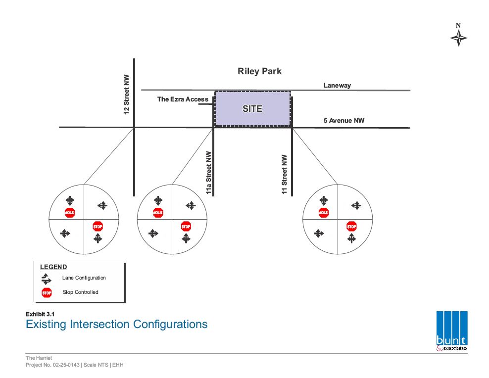
The Harriet on Riley Park is a new development proposed within the community of Hillhurst located immediately south of Riley Park on 5th Avenue NW next to the Ezra building.
The development is named after Harriet Waterhouse Riley, the wife of Ezra Riley, a politician and rancher, who donated the land that is now Riley Park to the City of Calgary in 1910.
The development of the parcel seeks to align the zoning and design with the Riley Communities Local Area Plan (LAP) through a redesignation application and development permit, applying the policies and targets within the document and in consultation with the Hillhurst Sunnyside Community Association (HSCA), neighbours, local stakeholders, and City of Calgary administration staff.
About the Site:
The parcel of eight lots comprises a full city block that is bordered to the North by a lane and Riley Park and is addressed to the South on 5th Avenue NW, situated between 11A St NW and 11 St NW, in the community of Hillhurst. The parcel currently contains 5 single-family homes, one duplex, and an apartment building (on the East end).
The surrounding context is the multi-family two-tower Ezra development to the West, and single-family homes and the Victoria on 5th building to the East. Across 5th Avenue are a vacant lot slated for redevelopment into multi-family small-scale building and single family homes.
The parcel is located 320 meters from the Sunnyside CTrain station, within the Transit Oriented Development area, and the Fifth Avenue bike path runs along the South side of the parcel.
1200 Block of 5 Ave NW
1220, 1218, 1214, 1212, 1210, 1206,
1204, and 1202 – 5 Ave NW


Policies & Guides
Several statutory and policy documents govern this parcel including:
Municipal Development Plan
The site is located within the Residential – Developed – Inner City Area as identified on Map 1: Urban Structure in the Municipal Development Plan (MDP).
Section 2.2 of the MDP promotes a more compact urban form that locates a portion a new housing within higher intensity, mixed-use areas that are well connected to the PTN.
Section 2.2.5 of the MDP encourages growth and change in low density neighbourhoods to accommodate developments that respects the scale and built form of the existing community. The existing low-density residential identity and character of the neighbourhood should be respected while ensuring infill developments completement the established character of the area (Section 2.3.2).
Section 3.5.2 of the MDP states that Inner City sites may intensify if the intensification is consistent and compatible with the existing character of the neighbourhood. Intensification strategies should modesty intensity the area and maximize front door access to the street.
Section 2.4.2 of the MDP: Built Form Policies Site and Building Design – “f. iv. Minimizing the shadow and wind impacts on adjacent residential areas and parks and open spaces.”


Neighbourhood Connector,
Map 3: Urban Form (pg 23, LAP)
Riley Communities Local Area Plan (LAP)
The Riley Communities Local Area Plan (LAP) Land Use Policy section indicates that development in Neighbourhood Connector areas should support a higher frequency of units and entrances facing the street.
The LAP identifies the subject parcel as
Neighbourhood Connector in Map 3 Urban Form.
The maximum building height allowed is up to
12-storeys as per Building Scale Map 4.
Section 2.2.1.4 provides Land Use policy in the Neighbourhood Connector Urban Form category, stating that development should be primarily residential; and support a broad range and mic of housing types, unit structures and forms.
Section 2.2.1.5 states that Neighbourhood Connector areas are characterized by a broad range of housing types along higher activity, predominantly residential streets.

Mid-rise (12-storeys),
Map 4: Building Scale (pg 24, LAP)
Urban Design Review Panel (UDRP)
This project meets the criteria for referral to Urban Design Review Panel (as identified in the Guide to Urban Design Review) and will be referred to the Panel (UDRP) for review during the Development Permit application process.
The UDRP is a Council-appointed peer review group of professional architects, planners, landscape architects, and engineers. Through their varied professional expertise, they encourage high design standards by providing independent, “best practice” review and comment on the urban design and architecture of development applications.

Applications
To achieve the new Riley Communities Local Area Plan policies and targets, a redesignation (rezoning) is required. The redesignation is being submitted as a stand-alone application at this time.
A subsequent Development Permit application will be submitted during the Redesignation application process and will be tied to the approval of the redesignation by Council.
Redesignation (Rezoning) Application – LOC2025-0133
Application Differences
An application for Redesignation from the existing Direct Control (DC) Bylaw 2016D34 District to a standard Multi-Residential – High Density High Rise (M-H3) district has been submitted to the City.
The application seeks to codify:
- A height maximum height of 12-Storeys (40m) to
align with the LAP. - A Floor Area Ratio (FAR)* of 6.0, allowing up to 198,750 SF of development (although the maximum FAR may not be achieved due to set-backs and step-backs).
Within the Development Permit application:
- Setbacks and stepbacks on the upper floors will be used reduce the impact of shadow onto Riley Park and improve daylighting of residential units in the development.
- The narrow laneway to the North, will be proposed to be converting to a pedestrian area with a design that matches the Ezra development to the West.
* “Floor Area Ratio” is a zoning metric that defines the ratio of a building’s total floor area to the size of the land parcel on which it is built. The Ezra development is noted as having an FAR of 4.0 allowed in the DC bylaw, with an achieved FAR of 3.3).
Redesignation / Zoning primarily deals with what land can be used for and the general parameters that govern development including:
- Types of uses allowed
- Density of units
- Maximum height and overall size of building (FAR)
- Parking requirements
- Public realm requirements
- Height and shape of development (max. envelope, not design)
- Set-backs and step-backs required (max. envelope, not actual design)
- Levy contributions
- May include overarching design requirements
Development Permits focus on the detailed design, safety, and regulatory compliance for specific projects within the established zoning framework including:
- Detailed site plan review and approval
- Building design, layout, and materials
- Utility connections
- Safety and accessibility compliance
- Construction and operations review
Building Permits validate that the detailed design and construction plans adhere to the Alberta Building Code, Calgary’s building standards, and all safety regulations.
For reference graphics of massing models, elevations, and footprint, please visit this site on a desktop computer.
Redesignation Design Brief
The developer has changed architectural firms and is developing new massing models for the site based on a standard M-H3 district Final layouts, massing, and renderings will be provided through the development permit application.
Redesignation Design Brief
An early Design Brief is due to be submitted to the Urban Design Review Panel for review.
Once available, the report will be uploaded here and presented to HSCA Planning Committee (Dec 8).
Draft Shadow Studies
The shadow studies are being updated based on the new M-H3 district zoning massing models to show the impact of the draft project design on Riley Park to the North.
Transportation Impact Assessment
This Transportation Impact Assessment (TIA) is based on the number of suites in the project and standard vehicle trips established by the City of Calgary for the area.
Public Engagement
This application is estimated to be a “1B” engagement rating on the Outreach Assessment Matrix from the City of Calgary requiring 4-6 outreach tools.

This application is utilizing eight Outreach Tools & Tactics to engage with stakeholders:
- This webpage for online engagement – EngageHarriet.com
- Direct Mailing of printed materials
(to neighbours within 2 blocks surrounding the site) - HSCA Planning Committee presentations
First will be May 26. A second presentation will be conducted in October or November 2025. - Public Open Houses – First was conducted on Wednesday, May 28. Further Open Houses will be conducted in late October with a wider deliver / mailing area and with City Departments in attendance and a wider direct mailing invitation area.
- Councillor / Ward Office meeting (completed)
- Local stakeholder engagement re: the 5th Ave Bike Lane improvements
- Email feedback form (below)
- Direct Contact email and phone provided (bottom of page)
Feedback
We remain open to your feedback, concerns and questions. Please use the form below to contact us.
We will forward your comments to the assigned file manager at the City of Calgary and reply to your questions.
Enter number into box and click enter to submit form.
Your Feedback
We remain open to feedback throughout the application process and will provide your concerns and comments to the file manager, or you may contact them directly.
The Applicant
Jennifer Dobbin
Dobbin Consulting Inc.
(403) 922-9365
je******@**************ng.ca
City of Calgary Contact
Jules Hall, Senior Planner, Community Planning – North
(587) 284-7444
ju*********@*****ry.ca
Please reference: LOC2025-0133